|
Association des propriétaires du lac Gagnon |
|
|
|
 |
|
Plan
d'aménagement forestier intégré opérationnel
(PAFIO) - 2013-2018
 (February
25) There is a public consultation under way
until March 12, 2015 on a portion of the
2013-2018 development plan. The Forestry
Ministry is still considering logging on the
east side of Lac Gagnon, between ch. du lac
Gagnon Est and ch. des Îles (Preston site). The
area under consideration is on the plateau in
Papineau-Labelle park, south of the Caroline
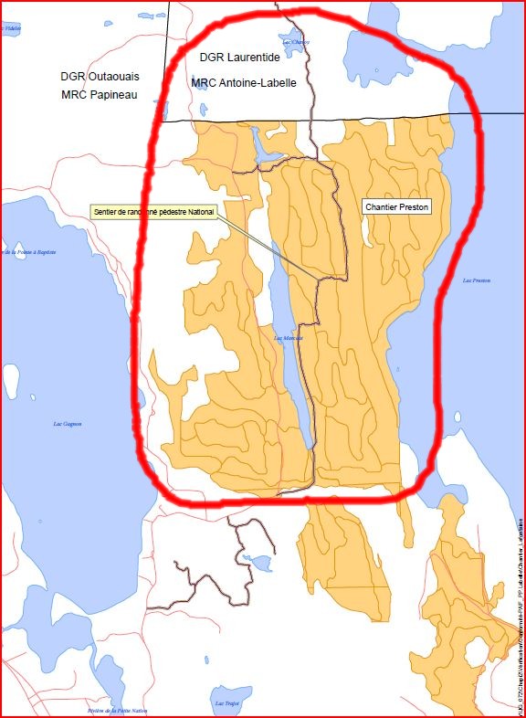
trail. (February
25) There is a public consultation under way
until March 12, 2015 on a portion of the
2013-2018 development plan. The Forestry
Ministry is still considering logging on the
east side of Lac Gagnon, between ch. du lac
Gagnon Est and ch. des Îles (Preston site). The
area under consideration is on the plateau in
Papineau-Labelle park, south of the Caroline
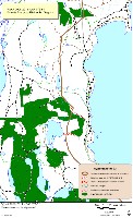
trail.The APLG has made representations to the Ministry to limit the logging to the top of the plateau and not along the side of the mountain along ch. des Îles. We also wanted to protect the beautiful specimens of white pine that are visible from the lake and the quality of the views along the route des Zingues. The development plan can be viewed online. You can also use the online form to submit your comments and suggestions by March 12, 2015. Click on the 'Fond de carte' tab on the black strip and select 'Imagery' to see the map in a photo format. Use the + and - signs in the top left portion to zoom back and forth. The green section at the top of the map represents a protected area, the Lac Gagnon old Forest. The yellow sections are subject to partial cutting, i.e. two thirds of the trees. The green-brown sections are subject to regeneration, in other words clear cutting. The aim of such clear cutting would be to replace tress with little economic value with more noble trees. Logging -
2014-2015
 (February
25) There has been some logging this winter a
few kilometers west of the lake (Lafontaine
site). Although the work will be finished by the
spring of 2015, transportation activities may
continue until the summer of 2015. (February
25) There has been some logging this winter a
few kilometers west of the lake (Lafontaine
site). Although the work will be finished by the
spring of 2015, transportation activities may
continue until the summer of 2015.Click on the map to enlarge it. Logging -
Winter 2014
 (February
18, 2014) The Ministry of Natural Resources has
recently approved logging work in an area
located at the north end of Lac Gagnon, west of
Route 6 and north of Lac Robillard. The logging
is already underway and should end before the
spring thaw period. If you wish to see the exact
location of this logging area on a map of the
northern part of Lac Gagnon click here
(PDF file 4.8 MB) (February
18, 2014) The Ministry of Natural Resources has
recently approved logging work in an area
located at the north end of Lac Gagnon, west of
Route 6 and north of Lac Robillard. The logging
is already underway and should end before the
spring thaw period. If you wish to see the exact
location of this logging area on a map of the
northern part of Lac Gagnon click here
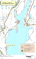
(PDF file 4.8 MB)Logging - 2013
 (June
22, 2012) In recent years, the APLG has negotiated
agreements with logging operators to restrict
logging activities around Lac Gagnon. These
agreements expire next year. From 2013, the
government, rather than the logging operators,
will decide on the areas to be exploited. In our
region, the organization charged with the task of
consulting interested parties is the CRRNTO, a new
agency. The APLG made representations to the
CRRNTO that the government protect identified
areas around Lac Gagnon from logging operations.
Two areas around the lake were identified for
logging: a limited area on the west side of the
lake, between ch. du lac Gagnon Ouest and the
mountain tops; and a large area between lakes
Preston and Gagnon, which includes the "Route des
Zingues" trail. Other interested parties also made
representations against logging in these areas in
the coming years. It is still too early to know
whether these interventions will bear fruit. The
APLG continues to monitor this issue. (June
22, 2012) In recent years, the APLG has negotiated
agreements with logging operators to restrict
logging activities around Lac Gagnon. These
agreements expire next year. From 2013, the
government, rather than the logging operators,
will decide on the areas to be exploited. In our
region, the organization charged with the task of
consulting interested parties is the CRRNTO, a new
agency. The APLG made representations to the
CRRNTO that the government protect identified
areas around Lac Gagnon from logging operations.
Two areas around the lake were identified for
logging: a limited area on the west side of the
lake, between ch. du lac Gagnon Ouest and the
mountain tops; and a large area between lakes
Preston and Gagnon, which includes the "Route des
Zingues" trail. Other interested parties also made
representations against logging in these areas in
the coming years. It is still too early to know
whether these interventions will bear fruit. The
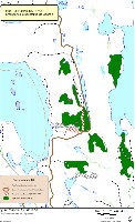
APLG continues to monitor this issue. Map of area west of Lac Gagnon (Lafontaine) Map of area east of Lac Gagnon (Preston) Selected briefs submitted to the CRRNTO: A.P.L.G. Maire de Duhamel Richard Chartrand Consult all briefs from the CRRNTO Report (5,2Mo.) (Updated
October 7, 2012) We are pleased to
announce that as a result of representations
made by the APLG, the Municipality and others,
the Government is removing the logging
activities that were projected around Lac Gagnon
from the 2013-2014 development plan. The plan
covered an area on the west side of Lac Gagnon
and an area on the east side of the lake which
includes the “Route des Zingues”. We will
continue to be vigilant to protect our
surrounding forests from logging.
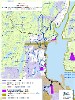
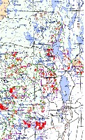
Click here to see the map of potential logging over the next season in the Lac Lafontaine area. Logging - Winter
2011
 M.C.
forêt inc. has conducted logging operations during
the winter of 2011 in an area east of Lac
Lafontaine, but outside the area protected by the
APLG agreement described below. Consult
the map
showing the territory covered and the types of
cuts. The proportion of trees
harvested was 30% in the areas identified as
"coupe de jardinage" and "coupe de préjardinage",
while the proportion was 70% in the areas
identifeid as "coupe progressive d'ensemencement
final". M.C.
forêt inc. has conducted logging operations during
the winter of 2011 in an area east of Lac
Lafontaine, but outside the area protected by the
APLG agreement described below. Consult
the map
showing the territory covered and the types of
cuts. The proportion of trees
harvested was 30% in the areas identified as
"coupe de jardinage" and "coupe de préjardinage",
while the proportion was 70% in the areas
identifeid as "coupe progressive d'ensemencement
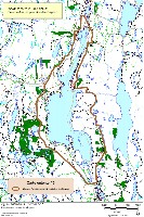
final".APLG Agreement
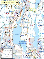  The
APLG reached its goal of protecting the outskirts of
Lac Gagnon from logging until the end of the
present 2008-2013 five year plan. All the
area within the line of the "zone de proximité",
as shown on the map , will be totally protected
from logging. The
APLG reached its goal of protecting the outskirts of
Lac Gagnon from logging until the end of the
present 2008-2013 five year plan. All the
area within the line of the "zone de proximité",
as shown on the map , will be totally protected
from logging.Due to a change in the policies of the Department of Natural Resources (MRNF) applicable to logging, our initial 2008 agreement with Lauzon Foresterie was likely to become useless. As a result of further negotiations in 2010, we succeeded in getting all 12 foresters operating in our region to endorse our agreement. In addition, the original agreement has been improved. Some parcels which were slated to be logged, for example, between lakes Gagnon and and Bourgeois, are now protected (see the map #3 below). We have also better identified the trails to be protected. Consult map #2 to see which trails will get improved protection. This map also shows which areas are in private hands. It should remembered that the agreements deal only with public land and do not apply to private land. These are identified on the map in beige. In addition to land owned by vacationers these sectors include undeveloped land, west of ch. du lac Gagnon ouest, belonging to Lauzon Foresterie Fiducie. In summary, all the periphery of Lac Gagnon made up of public land, up to the summit of the mountains, is protected until 2013. Mayors' Agreement
The mayors' agreement applies to inhabited lakes, located in the municipalities of Duhamel, Boileau, Mulgrave-et-Derry, Montpellier, Lac Simon, Ripon, Val-des-Bois, Bowman and Lac-des-Plages. For the purposes of this agreement a lake is considered inhabited if has five or more dwellings. The inhabited lakes in Duhamel are: Lac Gagnon; Petit Lac Preston; Preston River; Petite-Nation River; Lac Iroquois; Lac Chevreuil; Lac Doré; and Lac Lafontaine. The mayor's agreement, which expires in April 2013, can be summarized as follows:
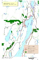
Logging for
the 2010 season
 (PDF format, 4 MB) 2008-2013 FIVE YEAR PLAN
The APLG is
concerned about the extent of logging activities
in the area of Lake Gagnon. The 2008-2013
five year plan submitted in 2007 by M.C. Forêt
included logging activities covering many sectors
very close to the shores of Lake Gagnon. The
APLG sought the intervention of government
authorities to limit as much as possible these
logging activities at lake Gagnon. After
long negotiations with M.C. Forêt and arbitration
from the Quebec Department of Natural Resources,
the APLG and "Lauzon planchers de bois exclusifs"
(Lauzon), as represented by M.C.
Forêt, have reached the following agreement in
2008:
The areas where logging is planned over the next five years are identified in green on the maps.
|
|
|||||||||||||||||||||||||||||||
|
|
|||||||||||||||||||||||||||||||||
|
|
|